The Missisquoi River - Sheldon Springs Rapids

The Stats

Location:
Sheldon Springs
Length:
.85 miles
Class:
IV
Flow Direction:
Southeast

Starting Elevation:
280′

Ending Elevation:
215′

Average Gradient:
75′ / mile

Rapid Type:
Big water boulder rapids.

Put in:
(-72.97343, 44.91212 ​)

Take Out:
(-72.98222, 44.90960 ​)

River Grade:  B+


The Sheldon Springs Rapids of the Missisquoi feature the largest volume class IV found in Vermont.  The run is short and sweet, with fun, continuous, in-your-face rapids.  Due to its residence in the lower reaches of a large watershed, the Missisquoi runs well after other rivers have dropped out.  To further add to the already ample opportunity to catch it with water, negotiated dam releases occur several weekends in the spring, and can be arranged when water levels allow throughout the year.  So the next time you crave some big water fun, check the guages, and head north.

Directions

Take route 105 to to Sheldon Springs.  Just as you are coming into town look for Mill St on the north side of the road. Stay on Mill St to the intersection of Shawville Road.  Take Shawville north past the paper mill and across the bridge.  The first left after the bridge will take you down past the solar farm to the takeout by the outflow of the power station.  Drive slow and park out of the way.  To get to the put-in backtrack back across the bridge and take your immediate right into the dam parking lot.  Follow the road across the small bridge over the penstock and park out of the way on the right next to the path leading down to the river.

Put-In

From the take out go back up the power plant road to Shawville Road.  Take a right across the bridge.  On the other side of the bridge turn into the dam access area and cross the small bridge across the penstock.  Park in the small gravel area by the woods and walk your boat down the path to the right.

Take-Out

The road to the takeout doesn’t appear on google maps (check satellite view to see it) as it is essentially a long driveway for the power company.  The turn is the first left after the bridge on Shawville road when headed north (the dam will be on the left when crossing the bridge).  Be sure to park out of the way and be friendly with any power company employees you come across.  Drive slowly.

FLOW INFO

The dam at the head of the run diverts 3500 cfs +/- for power generation, meaning the run will come in naturally on flows of 4000+.   Downstream ~12 miles is a USGS gauge in Swanton that is a good indicator of when that criteria has been met.  The USGS gauge in East Berkshire is ~15 miles upstream and will see water first.  This makes it a good indicator if the run is going to be coming in or dropping out in the future.  There are several good sized tributaries between this gauge and Sheldon Springs.

In addition to natural flows, the license for the dam operated by Enel Power stipulates they provide 6 recreational releases.  Unfortunately there is no reservoir meaning all releases are contingent on adequate flow in the river and advanced notice of a desired release by the boating community.  The conditions of the release flows are as follows:


1. A minimum of 2000 cfs is required for the release with the first
 1000 cfs going for generation and the balance to the bypass.


 2. Between 2000 and 3500 cfs, 1000 for generation and the balance to the bypass.


 3. Between 3500 and 6000 cfs, 2500 cfs to the bypass.


 4. Above 6000 cfs, 3500 for generation and the balance to the bypass.


Notifications of releases are generally posted to the Vermont Paddlers Club message board and facebook groups such as Vermont Class V

Online Gauge:
Missisquoi River @ East Berkshire, VT
Missisquoi River @ Swanton, VT 

Flow Range:
*Natural Flow*
East Berkshire: 2000 – 5000
Swanton:  4000 – 8000


Visual Gauge:
There is no visual guage, but an inspection of the dam and put in will give you a good sense for flow.  The dam will need a fair amount of water spilling over to fill the wide riverbed.

The image shows the put in and dam at a relatively high flow. 


The Run

Photos: S Gilbert

Ben Schott runs Tetanus Schott rapid on the Missisquoi River Vermont Whitewater Kayaking
Ben Schott in the middle of Tetanus Schott at a solid flow.

In a state nearly devoid of big water, the Sheldon Springs rapids of the Missisquoi provide reliable flows, allowing for boaters to get their high volume fix without travelling far.  The original discovery and descent must have occurred long ago, evidenced by the 1982 license for the dam operated by Enel Power.   The agreement stipulates the allotment of 6 recreational releases annually given adequate flow.  This condition was forgotten by the boating community and the run fell into obscurity until the late 2000s/early 2010s.  Then, largely thanks to the late Alan Panebaker, the condition of the license was rediscovered and through his work and that of Bob Nasdor and others, regular releases returned and the stretch saw a resurgence in popularity.  

Now the Sheldon Springs rapids are a mainstay for those looking to run big volume, often well after all other area creeks and rivers have dropped out.

The run itself is short and sweet, starting with a nice set of warm up rapids, which then lead to 4 big class IV rapids.  The wide riverbed allows for a choice of lines on pretty much all rapids, and given that you will likely do multiple laps, be sure to explore the options.  There are a few spots to avoid, and swimming would be an unpleasant experience if done in the lower half of the run as the final 3 rapids flow together with little respite in between.  Flows will also provide very different experiences.  At low levels you may be surprised to find sticky holes where at higher levels existed fun crashing waves, so be sure to travel wisely if the level is a new one to you.


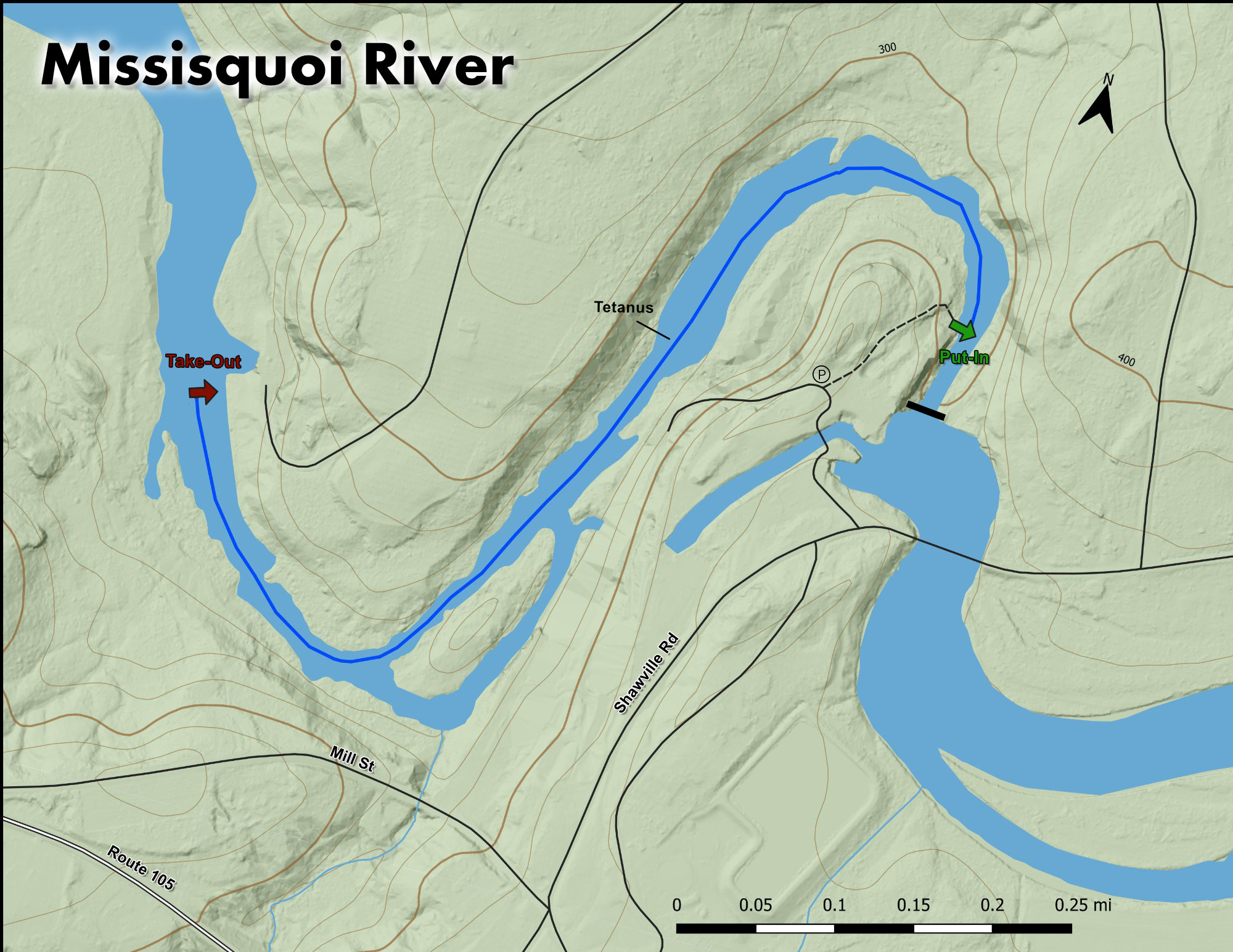
Before you put on you can walk down the road to the left of the parking lot to get a glimpse of the largest rapid – Tetanus.  If this doesn’t look like your idea of fun it may be best to not suit up.


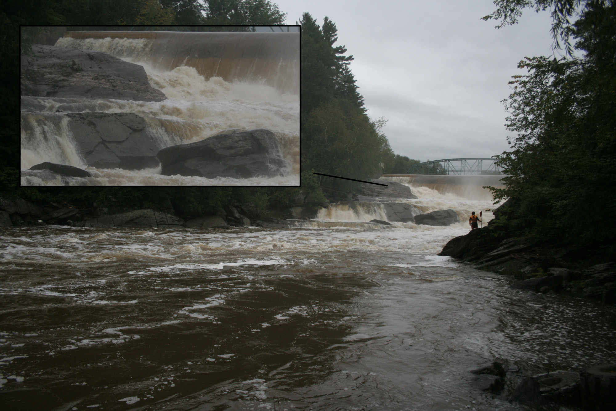
The warm up is fun and starts just a hundred feet downstream of the put-in.  A handful of nicely spaced class III rapids let you surf and move around the river.  These continue as you come around the first corner to the top of Tetanus Schott.  Tetanus is the biggest rapid on the run and is best scouted from the right.  At most levels the crux is avoiding a sticky hole placed perfectly in the middle of the rapid at the bottom with only small lines to the left and right allowing safe passage.  At its stickiest the hole can give some solid rides and often results in a swim.  Fortunately there is 100 yards of moving water below in which to collect the pieces.  At higher levels the crux is threading the needle between two holes in the middle of the rapid and then holding tight over the big crashing waves in the runout.


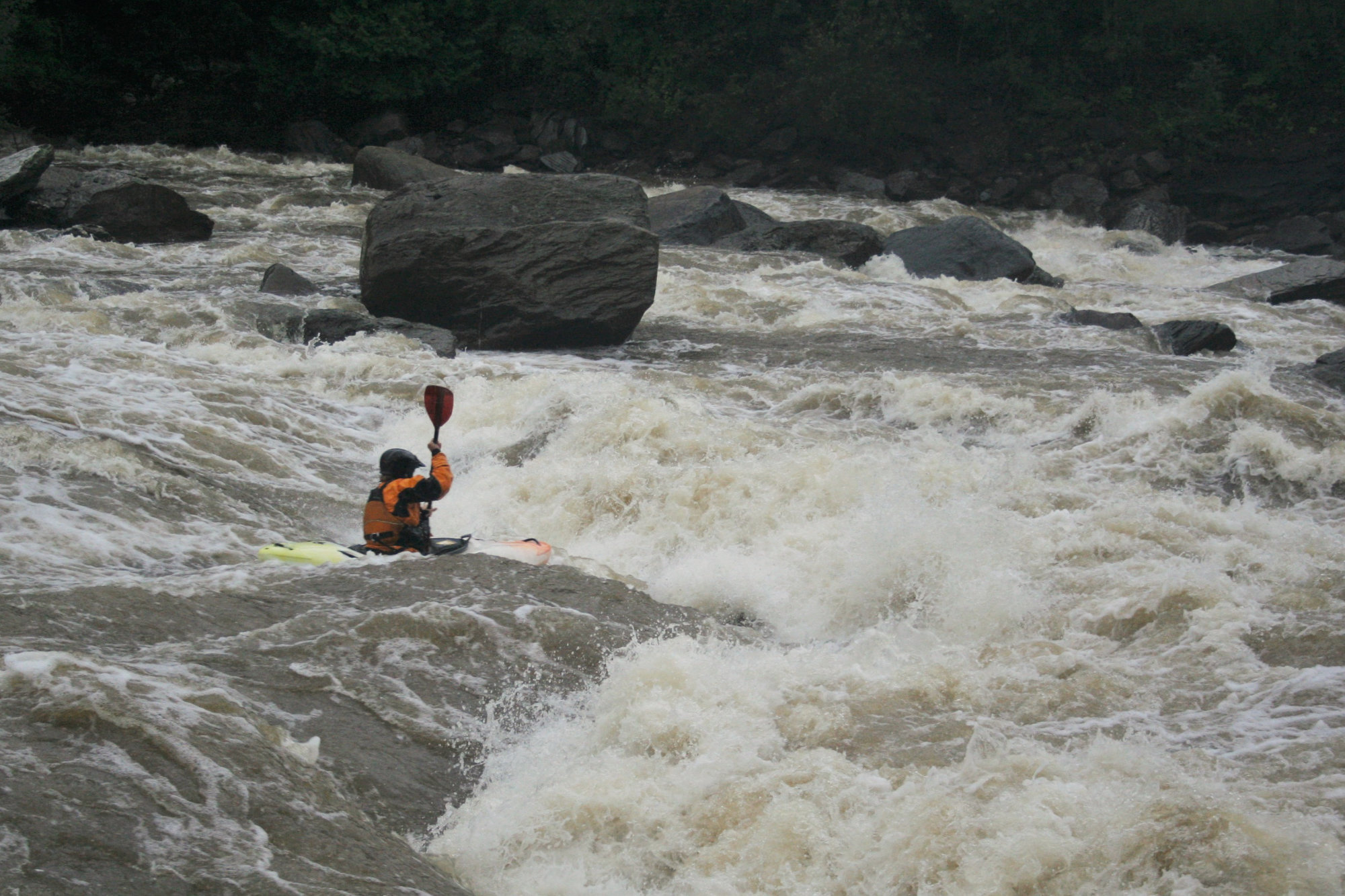
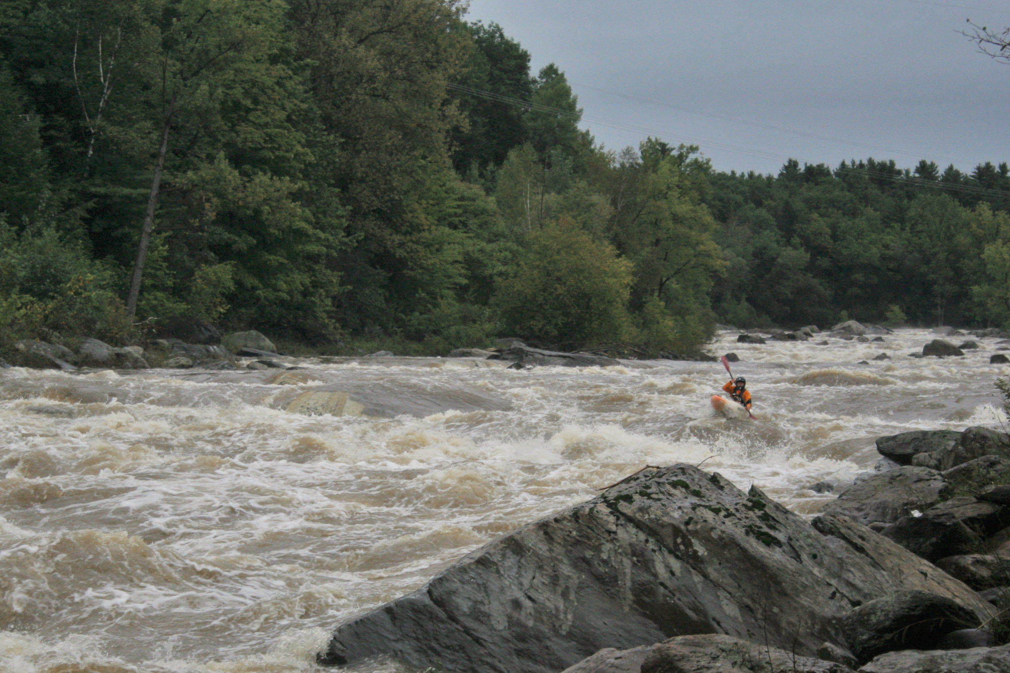
After Tetanus and the short section of flat moving water, come the next 3 rapids, which are stacked in quick succession.  These are somewhat difficult to scout but can be done from river right or left.  The first of these involves avoiding a hole on the left at the beginning, punching through a crashing hole at the end on the right and then catching the eddy on river left to set up for the final two rapids.  Be aware here that 100 yards below this rapid on river right is an unpleasant looking hole that could have some real teeth at higher flows.

The final two rapids are generally run on river left, moving around, over or through the crashing wave-holes that form at various levels.  These are easiest to scout from river left.  The run then gives way to class II and the take out on river right just above the outflow from the power station. 


A first time run at solid flows with scouting can take about an hour.  Once you are familiar with the run it can be done in less than 10 minutes if one were so inclined. 


Multiple laps are the norm.  Be sure to drive slow, park out of the way and be respectful of the power company employees, they have been very friendly and accommodating. 

Ben Schott runs a rapid on the Missisquoi River Vermont Whitewater Kayaking
Ben takes the hero line through a big hole on Big Schott - Tetanus is visible in the background.

Stepping Stones

Creek VT river guide coming soon
Not quite ready for The Missisquoi? The North Branch of the Lamoille is a great place hone skills.
Guide to the Trout River Vermont Whitewater Kayaking
If you like The Missisquoi, then head to the mountains and enjoy The Trout River
Ridley Brook guide Vermont Whitewater Kayaking
Looking to step it up? Ridley Brook will satisfy those looking for more of a challenge.