The Trout River

The Stats

Location:
Montgomery Center
Length:
2.45 miles
Class:
IV+
Flow Direction:
West

Starting Elevation:
900′

Ending Elevation:
530′

Average Gradient:
150′ / mile

Rapid Type:
Boulder Gardens, Bedrock Rapids & Falls.

Put in:
(-72.56440, 44.87845 ​)

Take Out:
(-72.60794, 44.87703 ​)

River Grade:  B+


Just below the Canadian border, lying in the shadow of Jay Peak, flows the Trout River.  Though often overlooked in favor of runs further south, those who venture to the clear waters of this mountain stream always leave satisfied.  The river valley features a remote feel, wild fauna, and excellent scenery.  In 2014, the Trout was designated as Wild & Scenic the first in the state.  And while the aesthetics are argument enough to visit, the whitewater is terrific as well.  The rapids are varied and entertaining with several highlights and enough action to keep things interesting for its length.  Whatever the reason, the Trout is well worth a drive up North.

Bill Hildreth profile picture Vermont Whitewater Kayaking

Meet Your Local Guide:

 
Bill Hildreth


You would be hard-pressed to find anybody more intimately familiar with the rivers and creeks of northern Vermont than husband and wife duo Bill & Joan Hildreth.  There is perhaps none they know better than their backyard creek – The Trout.


Homebase: Montgomery Center, VT
Local Runs:  The Trout River


Favorite VT River:   Next one that he hasn’t run yet. 
Favorite VT Rapid:  Unnamed Rapid on Calavale Brook
Favorite Run Outside VT:  Tie – Gulf Hagas, ME & Upper Pemi, NH

Directions

Find your way to the junction of 242 & 118 in Montgomery Center.  Opposite where 242 tees into 118, is the Snowshoe Lodge & Pub.  Adjacent to the pub is a parking lot that can be used for the takeout (across from Sylvester’s Market).  To get to the put-in take 242 for approximately 2¼ miles and turn right onto Amidon Road.  The put-in is ¼ mile down the hill where Amidon Road crosses Jay Brook.

Put-In

From the take out go up 242 for 2.25 miles, turn right onto Amidon Road, follow for another .25 miles and put in at the bridge across Jay Brook.

Take-Out

Use the parking lot opposite Sylvester’s market (next to the pub).  This is on river right the river goes under the 118 bridge.

FLOW INFO

Online Gauge:

Missisquoi River Near East Berkshire, VT
Missisquoi River Near North Troy, VT


Flow Range:
Insufficient Reports For Correlation
Submit A Report Here


Visual Gauge:

Downstream of the 118 Bridge in Montgomery is a painted gauge on the river left retaining wall.  The gauges is 4 solid lines and one dotted line.


Dotted Line: Low
1st Solid Line: Medium
2nd Solid Line: Medium High
3rd Solid Line: High
4th Solid Line: Very high.

The Run

Description: B Hildreth | Photos: S Gilbert

Safety notes: 

Be careful as towards the bottom of the run (after the large boulder garden), especially if the water is up.  There is an unrunnable falls with a continuous lead-in that can come up quickly.

Simone Orlandi portages a log on the Trout River Vermont Whitewater Kayaking
Somewhere in the warm up. Wonder where that cat went?

The Trout River, recently recognized as a Wild and Scenic River, the first in Vermont, Is a beautiful Northern Vt whitewater stream.  It begins at the confluence of Jay Brook and Wade Brook then falling into Montgomery Center via many Class 3 and Class 4 rapids, increasing in difficulty as you make your way downstream (overall Class IV with one carry). 

About a third of the run is on either Jay Brook or Wade Brook, the typical put ins.  The Wade Brook section, to Jay Brook confluence of the Trout River, is longer and somewhat more constricted and technical than the Jay Brook.  Each offers a little different ride, with Jay Brook seeming to be everyone’s favorite.

Simone Orlandi runs a rapid on the Trout River Vermont Whitewater Kayaking
Simone on a fun wall ride.
Simone Orlandi scouts a rapid on the Trout River Vermont Whitewater Kayaking
Simone gives the thumbs up after scouting the boulder garden.

 The river is mostly boat scoutable with some obvious spots where a scout is helpful in finding a suitable line.  You’ll encounter many different types of rapids from boogie water, boulder gardens, slot moves through gigantic boulders and of course the back to back waterfalls as you end up in Montgomery Center.  

After the confluence of the two brooks, the river does change its character a bit by having more rapids that need scouting, with house size boulders and ledges becoming more normal.  In here you will find a great slot move on river right, and a sizable 4-stage boulder garden featuring a screaming 90 degree left hand turn starting from river right (scouting is available from River Left, easiest). Your fun should be tempered by the fact that soon, at the beginning of the “Three Holes” swimming area, is an unrunnable falls (~20 footer) just after where the houses begin to show up on river left, close to the take out. Look for a large eddy on River Right to portage from.  Be careful above the portage waterfall because the action leading into this is non-stop for probably 50 yards without eddy sanctuary. Know where this is!

Simone Orlandi runs a boulder garden rapid on the Trout River Vermont Whitewater Kayaking
Simone in the middle tier of the boulder garden.
Simone Orlandi runs a rapid on the Trout River Vermont Whitewater Kayaking
Simone entering the fun rapids below the falls.

 You can get back on the river at the end of the portage either in a nice pool above the two back to back smaller falls or continue a few more yards to the base of a tributary on River Right (Hannah Clark Brook) and then do the remaining ½ mile to the take out with some very nice ledges and boogie water

Author’s note*

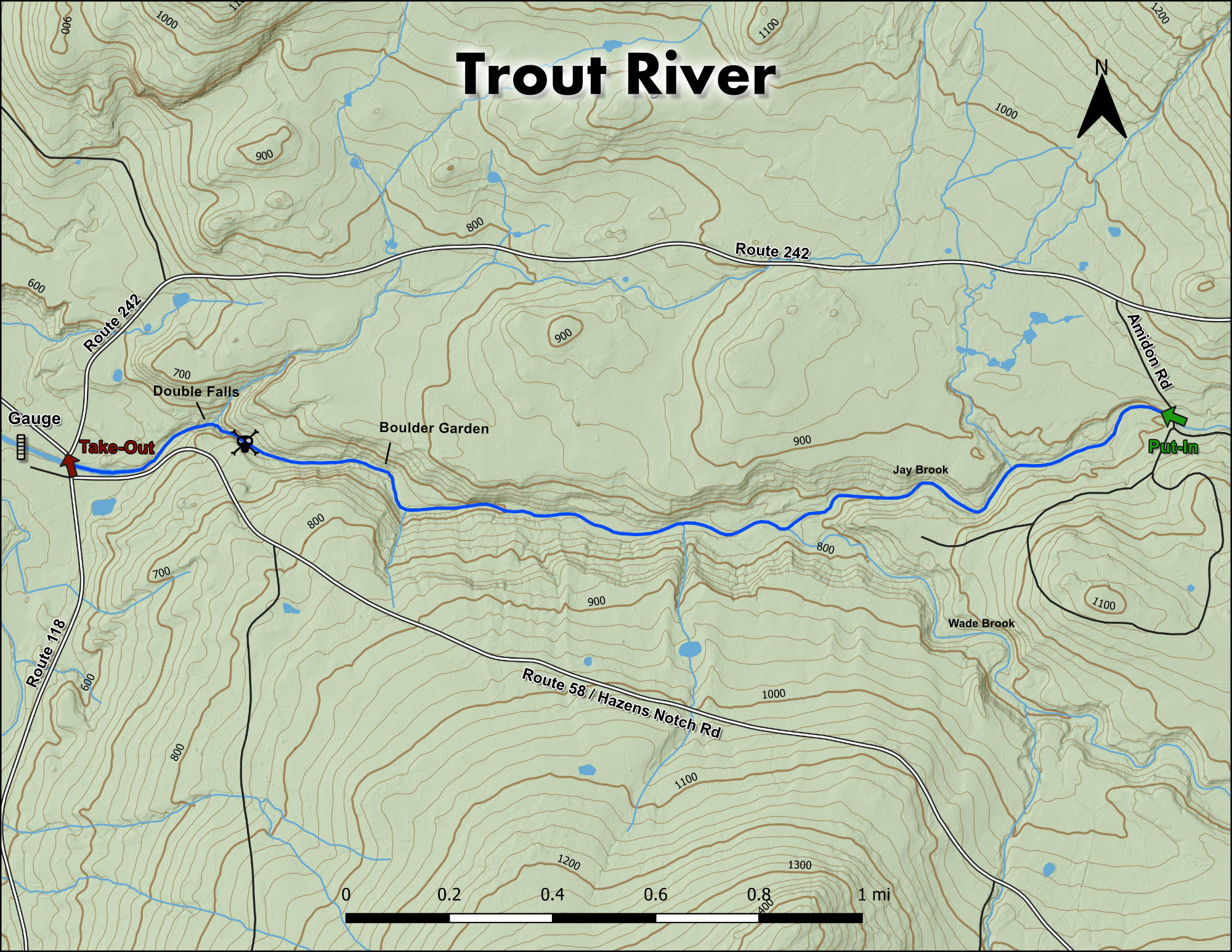
If you want to do a nice scouting hike along the river, there is a snowmobile road on River Left, off of a large open field, where Rte. 58 in Montgomery Center, heads towards Hazen’s Notch and turns from asphalt to dirt (intersection of Regan Rd, ~ ¼ mile at top of hill).  This VAST trail follows the Trout all the way up and along Wade Brook until the crossing of Amidon Road. Wade Brook’s put in is (approximately 3 miles) via this trail. When you cross the field towards the right, the road travels upstream, but if you want to see some of the bigger drops head downstream.  There are many spots where you can walk along the drops, you will be able to go below the houses and check out the portage drop and understand why you need to shoulder your boat (~ ¼ mile downstream).

Stepping Stones

Creek VT river guide coming soon
Not quite ready for The Trout? The North Branch of the Lamoille is a great place hone skills.
Guide to Gihon River Vermont Whitewater Kayaking
If you like The Trout, then you're sure to enjoy The Gihon
Ridley Brook guide Vermont Whitewater Kayaking
Looking to step it up? Ridley Brook will satisfy those looking for more of a challenge.