The Moose River (Top)

The Stats

Location:
Gallup Mills (Victory)
Length:
7 miles
Class:
IV
Flow Direction:
South
Starting Elevation:
1770′

Ending Elevation:
1170′

Average Gradient:
85′ / mile

Rapid Type:
Bedrock ledges and rapids.

River Grade:  A-


The Top Moose is a true hidden gem.  Tucked away above Victory bog in a wild and remote area of the state it offers a long stretch of memorable rapids and drops interspersed by aesthetic boogie.  From fluid ledges landing in carved out pools, to mini gorges and multi-stage bedrock drops, this run is a jewel of the northeast kingdom and a must-run if in the area.   

Put-In

From the take out continue up Victory Road for just under 1 ½ miles till you come to the intersection in the tiny town of Gallup Mills.  Take a left and cross the river again, 500′ later turn right onto Radar Road.  Follow Radar road up the river for a little over 4 ½ miles until you come to a T.  Park here and put in at the large culvert where the West and East Branches of the river converge.

Take-Out

(Directions are from St. Johnsbury).  

Leaving St J head east on route 2 for approximately 11 ½ miles.  Look for Victory Road on the left.  Take Victory Road north for 8 ¾ miles until you come to a bridge across the river.  This is the takeout.

FLOW INFO

Online Gauge:
East Branch Passumpsic River Near East Haven, VT


Flow Range:
300 – 1200

Author’s note: 300 and falling during summer would be too low but 300 and rising would bring a good level as long as it was a somewhat sizable storm. 1200 and falling after localized heavy rains would yield a great high flow and if I were driving from several hours away especially in the middle of summer I would not want to see any less than 800 and falling. 300-500 (low good), 500-800 (Medium), 800-1200 (high).


Visual Gauge:
Upstream river left side of Gallup Mills Bridge on Granby / Victory Road

0 : Minimum for Gallup Mills to River Road
1: Minimum for Entire Run
2 to 3: Fun levels
4: High


Painted Gauge for the Moose River near Gallup Mills Vermont Whitewater Kayaking
Top Moose Gauge Location

The Run

Description: N Lesch-Huie | Photos: N Lesch-Huie

ACCESS NOTE There is a gate located just past Victory Town Hall on Radar Road that is closed till Memorial Day, making this run primarily a summer and fall run.

Kayaker descends a drop on the Moose River above Victory Bog Vermont Whitewater Kayaking - photo credit N Lesch-Huie
The first clean four foot boof into a beautiful carved out pool. Photo N Lesch-Huie

For me to paint a complete picture of what the Moose river is and how it feels would take away from all the adventure and excitement that doing a personal first descent is all about. Rivers are for paddling; the reasons why more paddlers have not flocked to the moose by the bus load bewilders me, as just 10 miles away lies Vermont’s premier mountain bike destination, The Kingdom Trails, so adventurous types are near frequently. Whatever the reason may be, this river needs to be paddled and experienced by all as it is one of the best, or perhaps the best, “Roadside Wilderness” run in the Northeast. 


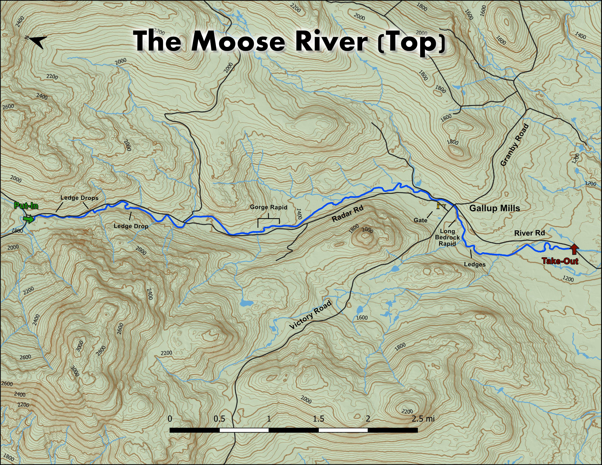
Embedded within large tracts of conservation land, state forest, as well as a tree farm operated by the Irwin Family since the 1940s is the mighty Moose river. The Moose gains its drainage from East Mountain which is a defining mountain in the landscape of the Northeast Kingdom. This mountain is so prominent that the Airforce picked East Mountain as a location for a Radar base to detect incoming potential threats from the Union of Soviet Social Republics (USSR) during the Cold War.


The Moose river can easily be accessed from 3 directions and if 4 wheel drive or gravel road navigation is your wheelhouse then the Moose is accessible from all 4 cardinal directions. Coming from the south via river road and passing through the Victory Basin Wildlife Management Area you can see the large bog that acts as an ecological sponge for the moose river creating a biodiversity and wildlife habitat that can only be compared to landscapes of eastern Quebec and Maine and reflects Boreal characteristics of biodiversity.


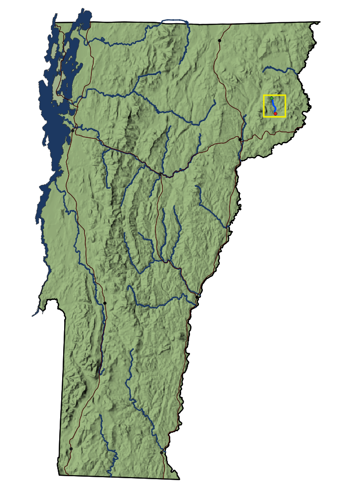
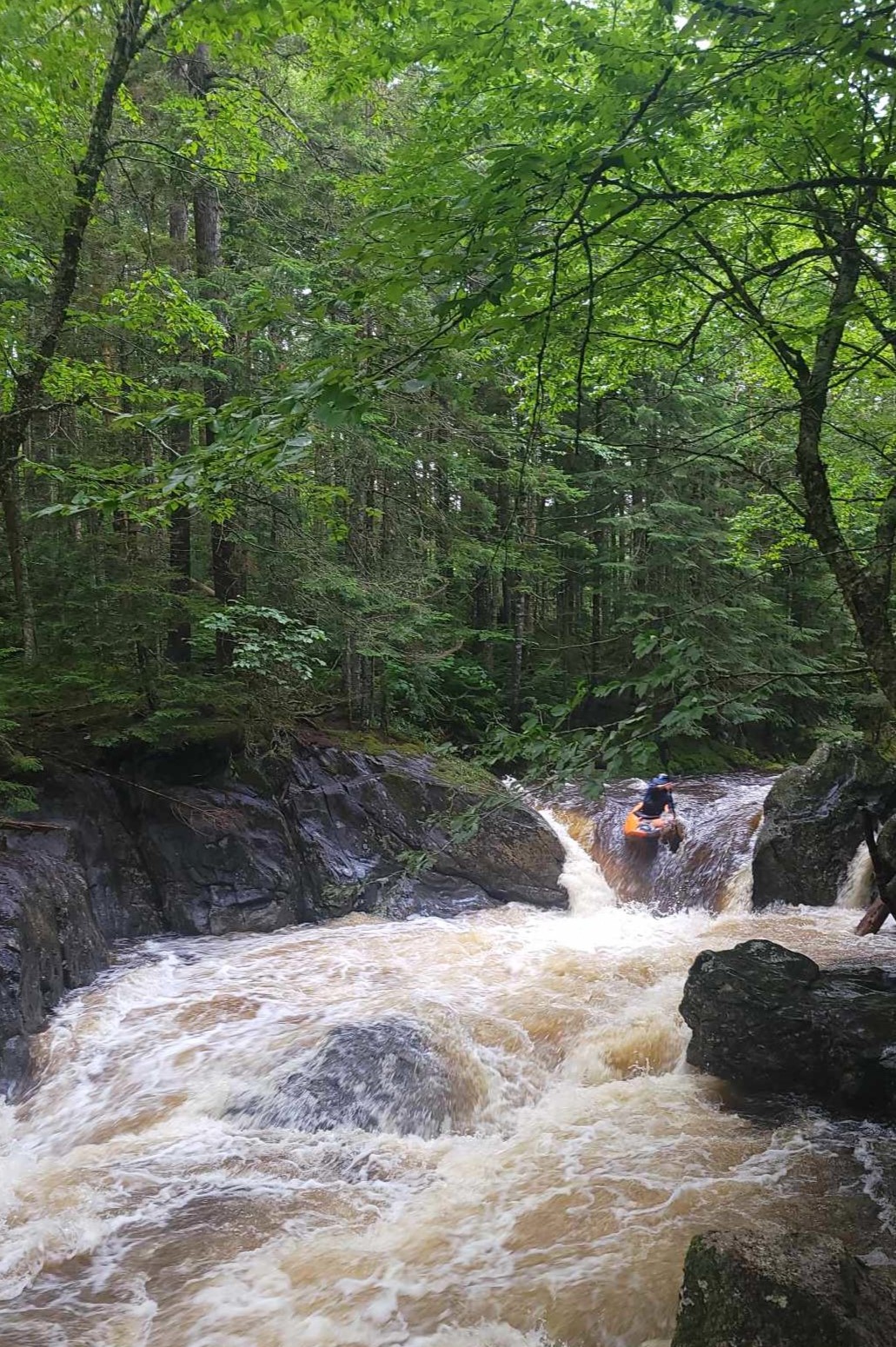
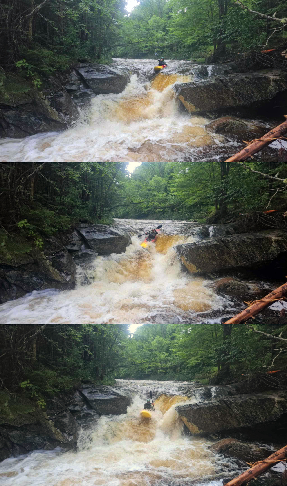
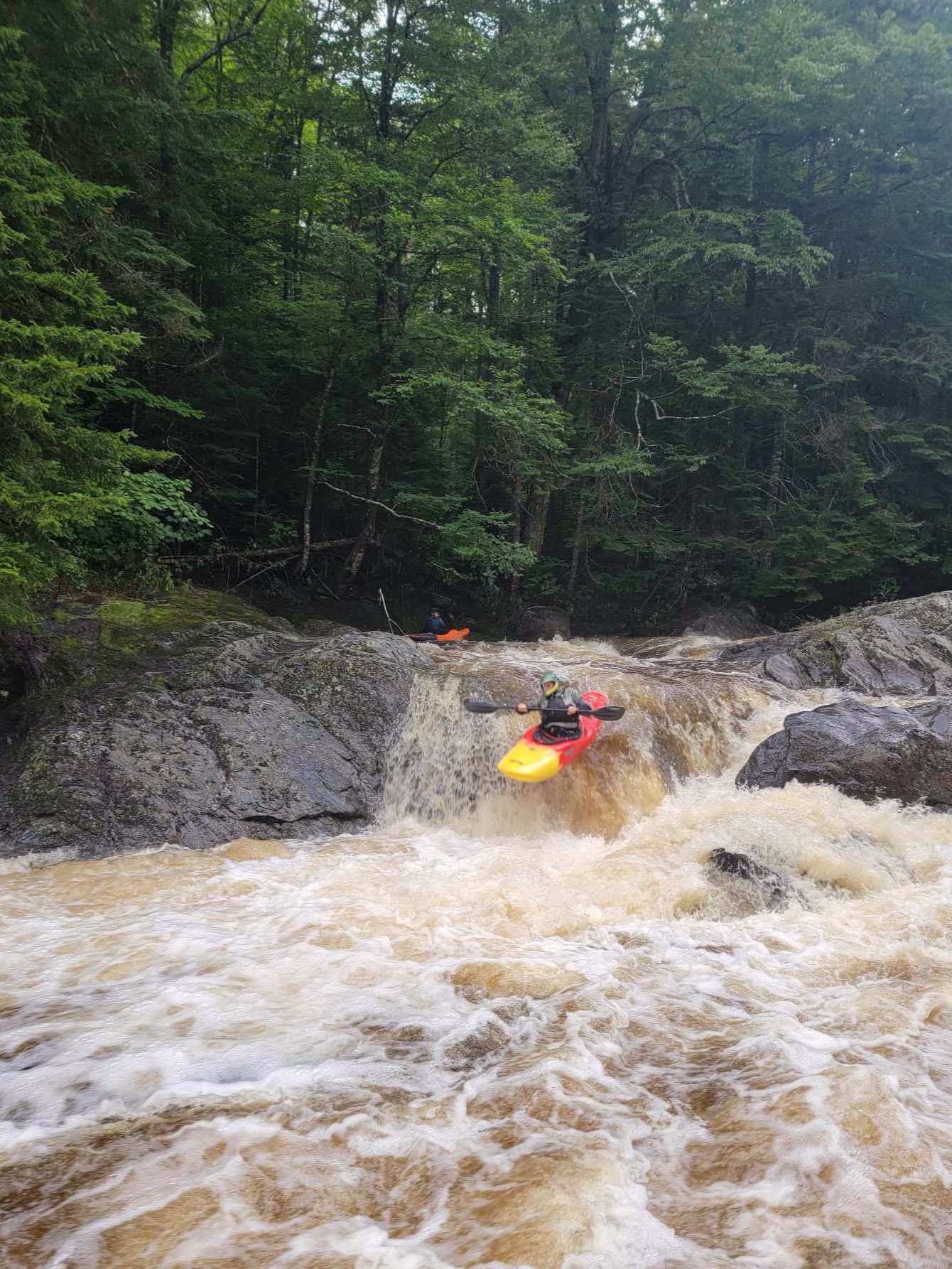
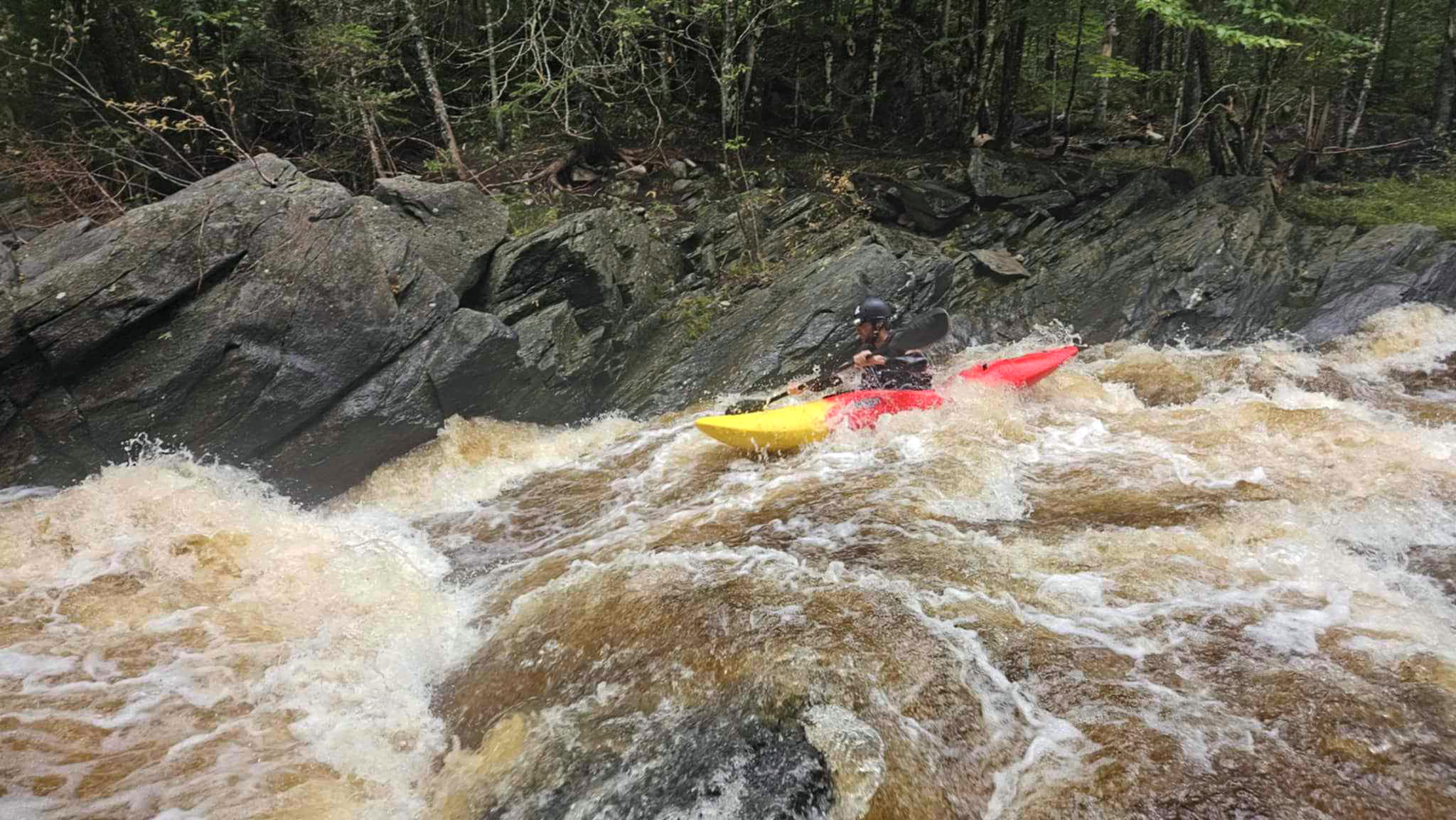
The Moose is not the hardest river around and also not the most stacked in concentration of rapids, but for those seeking the wilderness adventure kayaking experience with excellent rapids and a diverse river character, the Moose is most certainly one of the best in New England.

Most of the rapids are viewable from the road as you drive up but there are also many surprises awaiting within the Moose, secrets you have to unlock by sitting in your plastic vessel and traveling down the river. Names have been suggested over the years and probably different groups have them for different rapids on the river but what stands out is the character of the run. At least a dozen plus smaller rapids in the class 3-4 range and four larger scale rapids as well as a short boxed in gorge await for you in the Moose. The boxed in gorge and the larger scale rapids range class IV+ or class V- depending on the water level. One drop to note on upper creek section has a longer lead in toward large boulder/ protruding ledge in the center of river, a good eddy is on river right but if you miss the eddy you would be running a rapid where most of flow crashes into a large boulder and many people often portage this rapid. Above mentioned rapid is not easily spotted from the road, be mindful of lead ins that draw you in.


This section of the Moose is referred to as the Top Moose and has 3 distinct parts within it that all vary in rapid type and intensity. The run starts at the junctions of John Irwin Road and Radar Road at the previously described put in next to road just above a 4 foot boof or just below a large culvert going under Radar Road. The small pull out on the left just before this T intersection of John Irwin and Radar is the put in.  Walk the small trail to culvert or put in next to the road. This section has a creek style with tight turns into blind corners and gorgeous scenery in a beautiful Northern Hardwood, Spruce, and Fir forest. The Moss covered rocks and dense nature of the forest create a river vibe and wilderness experience that matches any in New England despite the whole run essentially being roadside. 

Kayaker descends a drop on the Moose River above Victory Bog Vermont Whitewater Kayaking - photo credit N Lesch-Huie
One of the drops in the creekier upper section of the run. Photo N Lesch-Huie
Kayaker descends a drop on the Moose River above Victory Bog Vermont Whitewater Kayaking - photo credit N Lesch-Huie
Cruising down the Moose. Photo N Lesch-Huie

At the bridge over the Moose where John Irwin Road intersects with Line Brook Road is a large pull out where you could park for a take out if you were interested in doing just the upper more creek style section. Below the intersection of Radar Road / Line Brook Road and to where the Moose passes through the booming metropolis of Gallup Mills is a much more wilderness adventure boreal tour with a very notable class 4+ 100 yard long gorge.


Below Gallup Mills and ending at the bridge over the Moose river on River Road is a wonderful section of beautiful ledge drops that should be scouted, as well as intermittent class 3+ boogie water, this section ends with a paddle out through the boreal ecological wonderland to the takeout at river road. The Moose must be paddled to be appreciated and unless you are a complete snob and hater of all things that make adventure wonderful this is an undeniably incredible place.

If you arrive at the Moose and find it too low then you can usually scrape out a run on the section from downtown Gallup Mills to the crossing on river road. This can be paddled down to around zero on the boaters gage. For a complete run from the Radar Road / John Irwin Road T intersection down to river road bridge crossing a minimum level of 1 on boaters gage is best, of course there is always a little fudge room. This complete run is over 7 miles long, making it a long run by New England standards.


Maps list multiple names for the primary road that runs from Gallup Mills up along the Moose river but locally the road is generally referred to as Radar road as it leads up to the old Radar Base. Listed on maps as John Irwin Road / Moccasin Mill Road, and Radar Road you will know your on the correct road as you pass the Victory Town Hall right after you turn onto the road leaving from downtown Gallup Mills. 


Correlation for this run is generally very accurately obtained by looking at the East Branch of the Passumpsic gauge. The Moose river gauge is not a good correlation for this section as the Victory bog / wildlife basin acts as a sponge or giant water displacement and water takes a long time to fill the bog / basin before the water passes through and down to the gauge in St. Johnsbury area.

Kayaker descends a drop on the Moose River above Victory Bog Vermont Whitewater Kayaking - photo credit N Lesch-Huie
A nice sideways ledge boof on the upper section of the run.
Kayaker descends a drop on the Moose River above Victory Bog Vermont Whitewater Kayaking - photo credit N Lesch-Huie
Part way through the bedrock rapid below the Gallup Mills Bridge. Photo N Lesch-Huie

This area is loaded with activity and adventure; beautiful bog walks, exploration of old radar base, incredible mountain biking, at nearby Burke Mountain as well as the Victory trails up Victory Hill road just off River Road, and also other great sections of whitewater on the Moose river. If you arrive at the upper Moose and find it to be in flood stage or too high there is an upper section above the T-intersection for regular put in, but it would be quantified as adventure steep creeking and starts out less than five feet wide. For this section you would take out at regular put in and drive up road toward Radar Base, take right at T intersection just above put in, until you find a spot that looks reasonable to put in. Lower down below the Victory Basin Wildlife Management Area is an incredible class 2/3 section that can be run at any water level as well as many miles downstream there is an urban class 3+ section in downtown St. Johnsbury. 

Because of this runs location in Boreal-hardwood, fir, and spruce forest-wood is always an issue and frequently moving around. Most frequent drops for wood are; the larger drop next to road on the upper creek section above Line Brook road intersection, where river turns to right and goes under a snowmobile bridge, the “Moose Cootch” (Gorge), and a large multi stage ledge drop just below Gallup Mills crossing on Granby/ Victory road. The gorge should be scouted on the drive up or a small eddy exists on river right as you come downstream but it sneaks up on you fast and people have accidentally paddled into the gorge blind at highwater and reported a great feeling of fear and exhilaration upon successful exit.

Kayaker descends a drop on the Moose River above Victory Bog Vermont Whitewater Kayaking - photo credit N Lesch-Huie
Nearing the final drop of the Bedrock Rapid below the Gallup Mills Bridge. Photo N Lesch-Huie
Kayaker descending a rapid on the Moose River above Victory Vermont
The second tier or a nice set of ledge drops below Gallup Mills.

This run is to be cherished and respected, be mindful of speeding into blind corners on these gravel roads as locals on 4 wheelers and large logging trucks are frequently moving about. 

Stepping Stones

Creek VT river guide coming soon
Not quite ready for The Top Moose? Try the Lower Section in St. Johnsbury to hone skills.
Guide to Joe's Brook Vermont Whitewater Kayaking
If you like the Top Moose you're sure to enjoy Joe's Brook in Danville
Guide to the Green River Vermont Whitewater Kayaking
Looking for a step up. Try The Green River in Morrisville.