The North Branch of the Winooski

The Stats


Location:
Worcester
Length:
2.40 miles
Class:
IV+
Flow Direction:
South
Starting Elevation:
1220′

Ending Elevation:
938′

Average Gradient:
118′ / mile

Rapid Type:
Ledge drops, slides and waterfalls


River Grade:  A

The North Branch of the Winooski is Vermont’s premier ledge-drop run.  Featuring nearly a dozen sizable bedrock rapids nestled in a beautiful and secluded valley, the “NBW” is a must hit when the water is up.  The run truly shines when padded out with a nice medium flow or better, which can prove very elusive.  But, if you practice patience and wait for the right day, you will reap the reward of one of the best runs Vermont has to offer.

Ryan McCall profile picture Vermont Whitewater Kayaking

Meet Your Local Guide:

 
Ryan McCall

Ryan was no fool when he chose where to live.  Residing a mere 15 minutes from the take-out, it is a good bet that location factored into his home-buying decision making.  As a result Ryan has more runs on the notoriously flashy NBW than anybody else.  He knows the rapids like the back of his hand and has even been known to run it solo.  But don’t worry we won’t tell.


Homebase: Montpelier, VT
Local Runs:  The North Branch of the Winooski | The Green River


Favorite VT River: The North Branch of the Winooski
Favorite VT Rapid:  Humble Pie – Green River
Favorite Run Outside VT:  Rock Run, PA

Directions

Head north out of Montpelier on Route 12 and keep on driving past the village of Worcester (grab your post lap beverages at LBJ’s to enjoy on your tailgate) and then keep your eyes peeled on the left for a river wide ledge.  That will be the end of the run. The parking area to drop your shuttle rig is just down river of this drop on the right. Continue on your drive north and you will cross the river at about the midway point in the run. Once you climb the hill keep an eye out for an old stone chimney from a long-gone cabin on the right.  Another 300 yards is another large parking area on your right. This is where you will park to put on the river. If you cross the river again, you have gone too far and need to turn around.

Put-In

Travelling north from the take-out, look for the next sizable pull off on the east side of the road.  It is approximately 2.5 miles north of the take-out.

Take-Out

The take-out parking is a large and obvious pull off on the east side of the road (river left) just downstream from the final falls.

FLOW INFO

Online Gauge(s):

Ranch Brook near Stowe, VT
Little River near Stowe, VT


Flow Range:
Ranch Brook: 90 – 350 cfs
Little River:  850 – 2250 cfs


Visual Gauge:

If you are coming from Montpelier and points south, there is a faded painted gauge below the bridge in Putnamville.  A healthy level would be 5 on the gauge and a minimum is 3.5.


Alternatively use the take out falls as indicator.


The image shows the take out falls at
Top: Very high (perhaps too high)
Middle: Medium high (great level)
Bottom: Absolute minimum (arguably too low)


The Run

Description: R McCall | Photos: S Gilbert


The North Branch Winooski…  If you know, then you know.

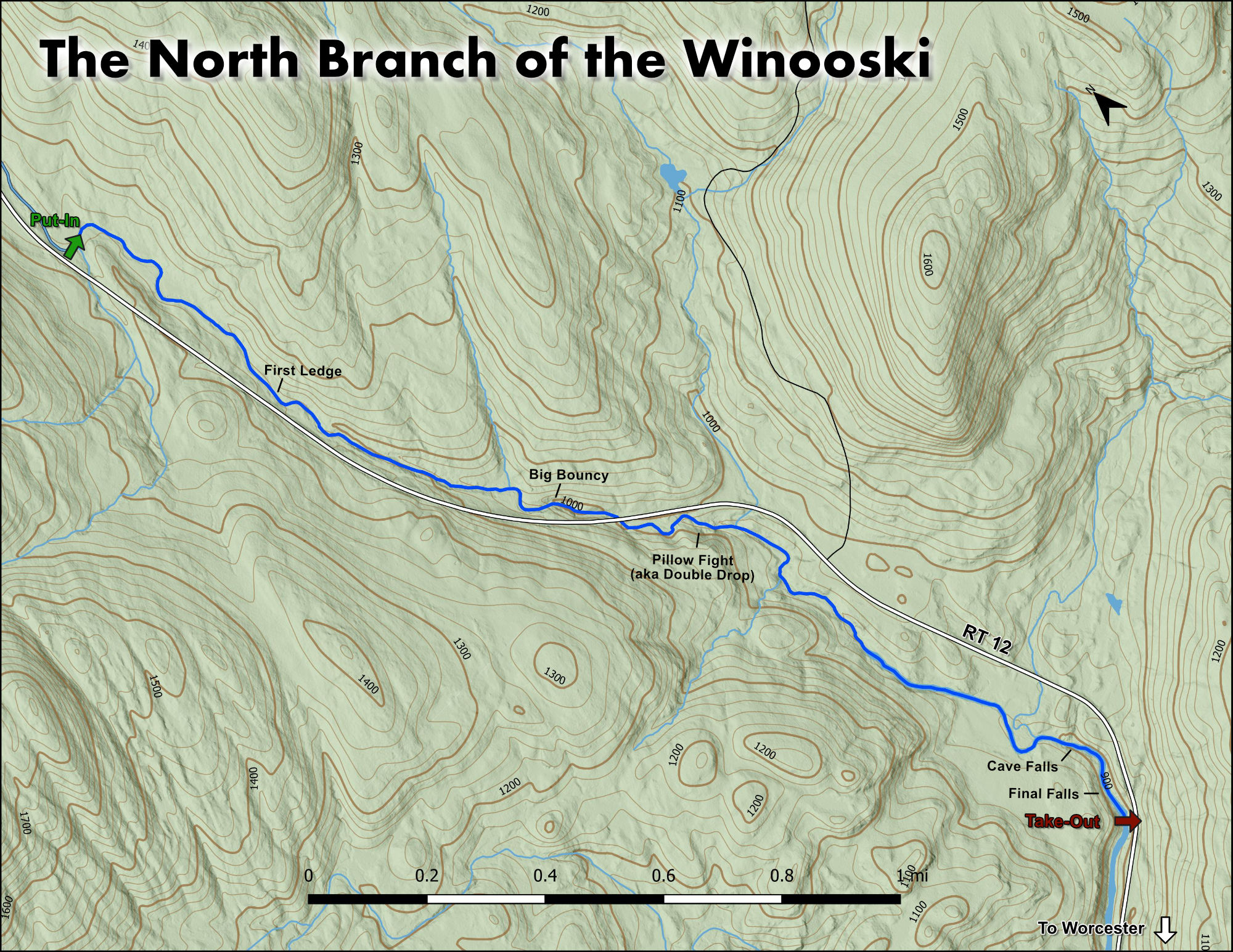
I fell in love with this river on a random day while my wife and I were looking for housing for our big move to VT back in 2003.  We were looking at various options all over Central VT from Warren to Hyde Park and Waterbury to Barre. Getting from one rental to the next we crisscrossed all over Washington and Lamoille Counties.  While scrambling to get to a showing in Morrisville from one in Montpelier, I decided to take the route less traveled to avoid the Route 100 shitshow. It was early may and it was wet so most rivers in the are had some water in them.  Up Route 12 we went and along the North Branch of the Winooski. It looked like an amusement park of drops and cascades that I was craning my neck to see as we were whizzing along to our appointment. I know I had to get back to this river to get a better look at the river closer once we made our move to VT.  What I didn’t know was at some point, 2 years later, we would buy our current home 15 minutes from the take-out.

Take note of your surroundings once you get parked.  Its one of the few places that you are in true VT wilderness.  No power lines, no cell service, no people… You are in an area that the Vermont Land Trust, Vermont River Conservancy and the State of VT have locked down in conservation for perpetuity.

You get to slip into the river now – go ahead.  On the water, you realize its small, micro. The banks are no further than 15 feet apart.  The pool you are in should be moving some or you are in for a bumpy ride. It should also be deep enough to rip off a few practice roles.  Again, if not its going to be a bumpy ride.

You have about 300 yards and a brook comes in on the right and adds about another 1/3 of flow.  You can see where the old Cabin and stone chimney stands as well. From this point there are number of warm up rapids that are all read and run and in the class II variety.  

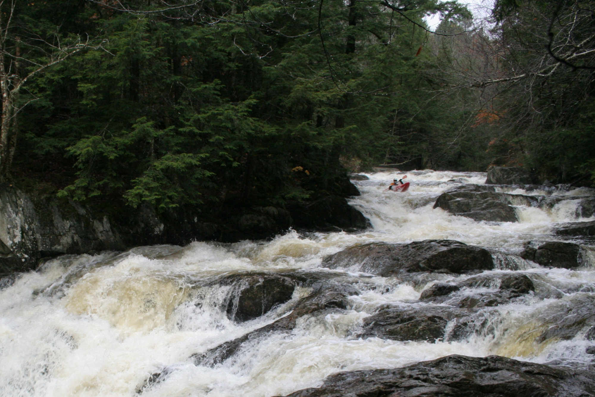
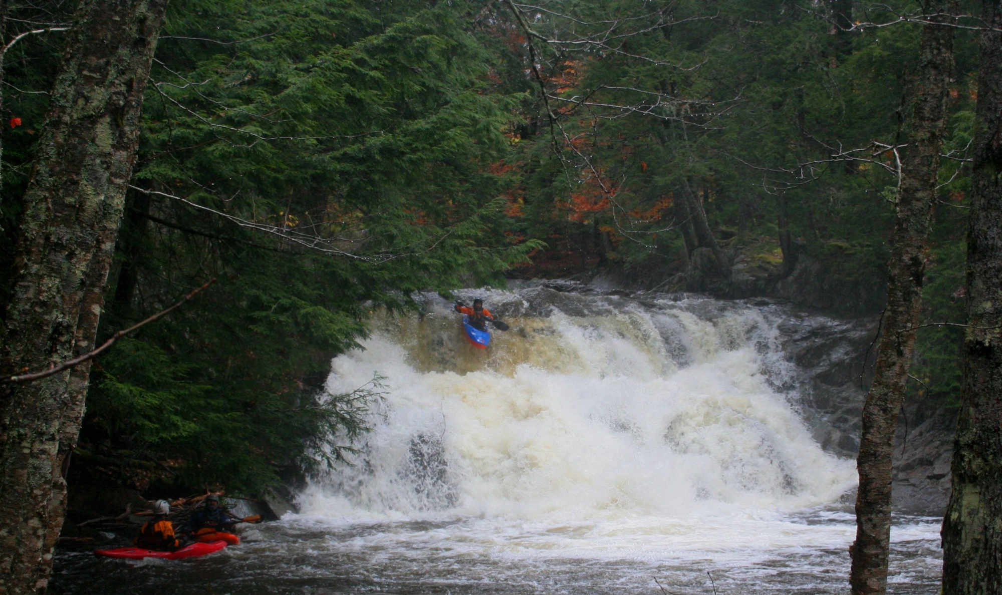
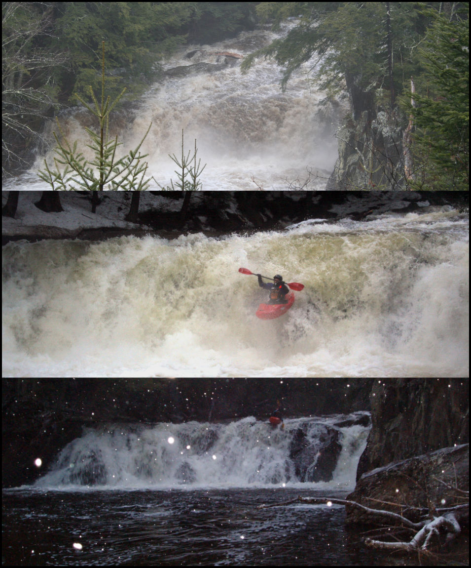
After a while you will come to a large eddy on your right where the water stacks up before making a hard left zig and then immediate zag right.  This is the eddy at the top of the Class III+Broken Falls. It’s a double drop of sorts with a ledge into a pool and then a 6 foot drop off the middle.  Make sure you are middle and get a late boof. There are pieces of the falls that have broken off and lay under the surface to both sides of the middle line.

Clay Murphy runs Big Bouncy Rapid on the North Branch of the Winooski Vermont Whitewater Kayaking
The lead-in to Big Bouncy at a medium level. The Crux move is just visible in the foreground.

Below here the river shells out one of the better class III progressions, the 3 Sisters.  Hump Back is first and is a fantastic boof. Catch the eddy above, follow the current and make sure to grab a paddle full off the lip.  Choke is next and also has a nice eddy to set you up at the lip. You want to flair off of this one heading left in the main flow. Lastly is Sister Chunk.  Pick your line and if the water is low, get right of the Bedrock at the bottom to be in flow.


Chunk leads directly into the Narrows.  This is a mini gorge of sorts and definitely the most narrow section of the river.  There are a few holes in this section, but its fun class II+ stretch.


As you leave the Narrows you come into some more garden variety class II rapids.  The last little rapid you should use to set you and your crew up for success. After you leave that rapid you are in relatively eddyless territory leading up to class IV Fine Line, the first of the major drops.  The lead into this has two micro eddies. The one river left does not allow you to get out to see the drop or your line. The one on river right is just out of sight and around the corner of the large boulder you can see from the above rapid.  It is recommended that you eddy hop to the river right eddy and get out so you can all get eyes on the drop. Going to river left eddy and then ferrying across to the river right eddy and out is the ideal move. The drop it’s self is a really fun drop and has two options for an auto boof to the pool below.  Both of these come on the river right line. It is recommended that you run the river right line as well. River left ½ way down the drop has a bottomless pothole that can swallow a boat. In the summer time the pothole is a great dunking pool. In total this drop gives you about 12 feet of verticality….. it’s a beaute.


After Fine Line, you wash around and under a prow of rock on your way to class III+ Manky-Mank.  It’s a two part rapid with Manky not having a decent line what so ever except at higher water levels and Mank begin decent as you start center and drive left.  When the water is up this is a pretty big drop in total of about 12 feet broken between the two sections in total and a visually pretty one to look back up at once completed.  Of note the island outcrop on Manky is under cut on the river right side.

Next up is the biggest rapid on the river equaling over 40 feet in total drop.  Once through Manky-mank, you should be aware of the hard right bend and then hard left bend.  Once through the left bend, you are in the straight away leading to the first class V drop, Big Bouncy, the biggest rapid on the river thatis over 40 feet in total vertical drop.  There are two ways to get a look at this rapid.  At the hard right bend, eddy out and walk the old Route 12 road along the river to several areas to view the rapid – it is also a relatively easy portage route.  The other option is after the hard left bend, eddy out on river left and scout the drop from that side. Running this rapid requires you to navigate two stacked ledges of 5 and 8 feet respectively and then lining up for the proper entrance to the remainder of the cascade.  My line of choice is headed downhill on the left of the prow at the horizon line. However, I have seen successful lines in this section of the rapid running far right as well. Either way don’t drift into the middle zone between these two lines because there is severe pin potential mid drop.  The drop culminates in in a pool where high fives and whoops are shared, solo or with your crew. Beware this is called Big Bouncy for a reason and has been known to eat boats if off line.

Double Drop aka Pillow Fight waterfall rapid Vermont Whitewater Kayaking
Erik Debbink drops Pillow Fight on a wet fall day.

After you leave the pool at the bottom of Big Bouncy, you are in a stretch that parallels Route 12 and ultimately runs through a culvert under the state route.  You should always get a view or have current beta that there isn’t a tree or logs spanning the culvert entrance because eddies are far and few in this stretch.


You have now completed the first half of the run and are on your way to the final stretch on the west side of Route 12.  After you exit the culvert, you have some swift water to navigate before class III+ Flat Falls. The river swings left and there is a beach to grab above the falls.  Get a look at the 8 foot drop and where to go off. At medium and high water, you can fire it off pretty much anywhere. Lower levels there is a clean boof off the center.  Beyond Flat Falls the river gets busy and at higher water things tend to flow together into the next drop.


The river necks down and works around a few outcrops.  As things swing back to the left and then disappear to the right, be on the wall on river left.  This is class IV Sliding Board. Its class IV because its easy to mess up and be stuck in the hole above a 35 foot drop.  If you are too far right you will spend an excessive amount of time in the hole at Sliding Board above Pillow Fight.


Once through Sliding Board, immediately eddy out river right or left.  Then get river left and get out to get a look at class V Pillow Fight. It’s a double drop that you run right of center at all levels.  The first part is a late boof onto a large pillow caused by a shelf that you can piton and pin on ½ way down if you don’t get your bow up.  After successfully landing this first move, you now have to continue to paddle and brace down the remaining 15 or so feet because you are being smashed by pillows crashing at you and your boat that will flip you if you auto-pilot to the pool at the bottom.  Pillow Fight is a big drop and requires you to be on-line and working. One thing to keep in mind, when the river is high, Flat Falls, Sliding Board and Pillow Fight tend to run together to create a monster of a rapid.


As you are paddling away from Pillow Fight, take a look back up at it.  Drops like this are what make the NBW special and unique.

Kayakers on a waterfall on the North Branch of the Winooski Vermont Whitewater Kayaking
Synchronized spectating at Cave Drop.

The next ½ mile is swift water with a few fun little rapids to keep in interesting.  Keep your eyes open, you may see a moose or black bear. As you are approaching the next rapid you will paddle through a yard and past a beautiful river-side home.  Past the home the river swings left and then over a short cascade and into some slack water above the next rapid, Class IV Cave Drop. Get out river left above the drop and get a look.  There are two options to run the initial entry. Either 10’ boof off the ledge over the cave or if flows allow, run the slide to the right of the vertical section and boof into the gorge from the side.  A word of caution, the hole below the vertical drop is sticky and the cave behind the curtain is real. It is over 8’ deep and I’ve heard Elvis lives back there. Once in the mini gorge, enjoy it and ride it out.  Another one to look back up at once you’ve run it. But don’t look for too long because there is a tricky class III ledge below that if offline will mess with you.

As you bank right and then left again, you are entering the straight away to a class V, The Last Drop (as in “good to the last drop”).  This is an impressive river wide waterfall that pending where you run it can be pushing 20’ tall on the left wall or closer to 12’ against the right wall.  You can eddy out at the top of the drop either right or left, although to portage, river left is recommended. There are a number of lines you can take on this rapid.  Starting on river left, there are a few diagonal ledges into pools above the vertical plunge against the wall. If you are directly on the wall, make sure to get a good boof because it is shallow those first few feet from the wall and the drop.  8 feet of the wall a pool forms and it is considerably deeper. Middle and right options, require you picking your line wisely for entering and riding various jets of water down a 30’, 20 degree slide to the vertical falls. I like center in medium flows with a giant paddle full of ledge at the lip.  A boof is mandatory. At higher levels river right is a pick and poke affair with a soft landing off of the edge. As a word of caution the center and right side lines have a hidden ledge that if you don’t get a boof, you will violently piton at the bottom. Get the boof and you will air it out.


After The Last Drop you have a couple of choices, eddy out and hike up the sketchy slippery path and through the trees to the highway and carry to your car a the parking area or paddle a little further down stream and look for flagging for a nice take out trail directly across from the parking area.  Either works fine and will get you where you need to be.


Of note:  If the NBW is too high, check out its tributaries.  Hancock (Class V), Minister (Class III+) and the Martins/Patterson combo (Class III) are all high-quality runs offering great micro creeking options in the same drainage.


Conservation:  The section from the put-in to the culvert is conserved by the Vermont River Conservancy.  This was a long process but is now protected. Old Route 12 parallels the river at river level, so people can hike along this stretch to look at the river and watch boaters on the rio.  It’s a beautiful walk.


Stepping Stones

Creek VT river guide coming soon
Not quite ready for the NBW? The North Branch of the Lamoille is a great place hone skills.
Guide to the Green River Vermont Whitewater Kayaking
If you like the NBW, then you're sure to enjoy the Green River.
Ridley Brook guide Vermont Whitewater Kayaking
Looking to step it up? Ridley Brook will satisfy those looking for more of a challenge.