The Lower Mad River

The Stats

Location:
Moretown
Length:
2.20 miles

(1.6 on the Mad, .6 on the Winooski)
Class:
III
Flow Direction:
North

Starting Elevation:
590′

Ending Elevation:
430′

Average Gradient:
100′ / mile (on the Mad proper)

Rapid Type:
Pool drop bedrock rapids

River Grade:  B+


The Lower Mad is the most popular stretch of whitewater in Vermont. Centrally located with easy access, a dependable gauge, and a wide range of flows means the logistics couldn’t be easier. The whitewater, consisting of well defined class III bedrock rapids is the perfect playground for any craft and a wide range of skill.   One trip is all it takes to understand how the Lower Mad has ignited and re-ignited the passion in Vermont paddlers for decades.  

Put-In

From the take out head east on route 2 for 1½ miles to 100B.  Take 100B for 2 miles to Moretown Common Road on the left (just before the bridge over the river).  Go up Moretown Common Road (dirt) for approximately ¼ of a mile.  Pull off on the right and take the path down to the river below the dam. 

Take-Out

From Exit 9 on I-89 head West on route 2 for 1 mile.  Very shortly after crossing over the Winooski River you will see a field with a dirt lot on your right.  This is the takeout.

FLOW INFO

Online Gauge:
Mad River Near Moretown, VT


Flow Range:
300 – 5000


Visual Gauge:
There is no dedicated visual gauge on the Mad as the USGS gauge is located upstream within a few miles of the put-in.  An inspection of the rapids at the put in will let you know what to expect on the run.

The Run

Description: M Clark | Photos: S Gilbert

Adam Carparelli eddies out on the first rapid of the Mad River Vermont Whitewater Kayaking
Adam Carparelli eddy-hopping down the first rapid of of the Lower Mad

The Lower Mad is one of the most commonly-run stretches of whitewater in Central Vermont. It runs regularly through Spring and Fall and will come up after any reasonable amount of rain during the summer months. It holds its water relatively well and can be scraped down as low as 250cfs and run upward of 5k. This stretch begins a short drive up Moretown Common Road and runs to the confluence with the Winooski River for a few hundred yards before one finds the take out on river left. You will know you’ve reach the put-in on Moretown Common Rd when you see a slight gravel pull-off on the right side of the road with the dam in view through the trees. Walk your boat down the steep hill to the bank of the river and as far up the bank toward the dam as is possible with the current flow. 

Be careful getting to the river from the put-in parking area during winter. The hill is steep and there can be lots of broken glass and metal scraps beneath the snow waiting to tear a drysuit. It is easy to lose your footing and end up butt-sledding down the hill with your boat in hand (or not). The take out is a well-maintained parking lot with a lower loop on rt.2 just after you drive over the Winooski River. This is an excellent run for paddlers of all skill levels- from those looking to take their first step up in II/III with little consequence, to more experienced paddlers who can choose harder moves and catch as many eddies, waves, and holes as possible. There is one more difficult drop, Horseshoe Falls, which is easily portaged on river left (the exception sometimes being winter/early spring paddling, when the portage can be blocked by ice). 


It is common to use the water at the put-in as a warm-up area. There are a couple of small waves, depending on the flow, and a wide area to practice ferrying and attaining. The first rapid below this area is formed when the flow becomes constricted to a ~20’ wide channel for 100 yards or so. Here, there are ample eddies on both sides of the river, a decent hole to surf, and a boof over a boulder toward the bottom at certain flows. Below this section is a pool which opens up into some light boogie and a small surf wave leading into the next rapid. At very high flows there can often be some interesting boils and eddy lines in this area to keep you on your toes.

The next rapid is a two-tiered drop with lots of opportunities for more advanced moves. Most paddlers will approach the horizon line from the river-right eddy immediately above the drop. From this location one can see that the upper part of the drop consists of a river-wide curler and a green tongue just below the eddy. Drop down the green tongue and diagonally across the flow to catch the eddy on river left. From this point, you can peel out into the flow and finish the second part of the drop. The main flow at the bottom of this second tier flows directly into a large boulder, which can have a nasty hole on the right side at very high flows. The smoothest line in to go right of the boulder. There is some decent surf on the bottom wave of this drop at some flows.

Adam Carparelli heads into S-Turn as Clay Murphy looks on from below. Route 100B bridge visible in the background. Vermont Whitewater Kayaking.
Adam Carparelli heads into S-Turn as Clay Murphy looks on from below.

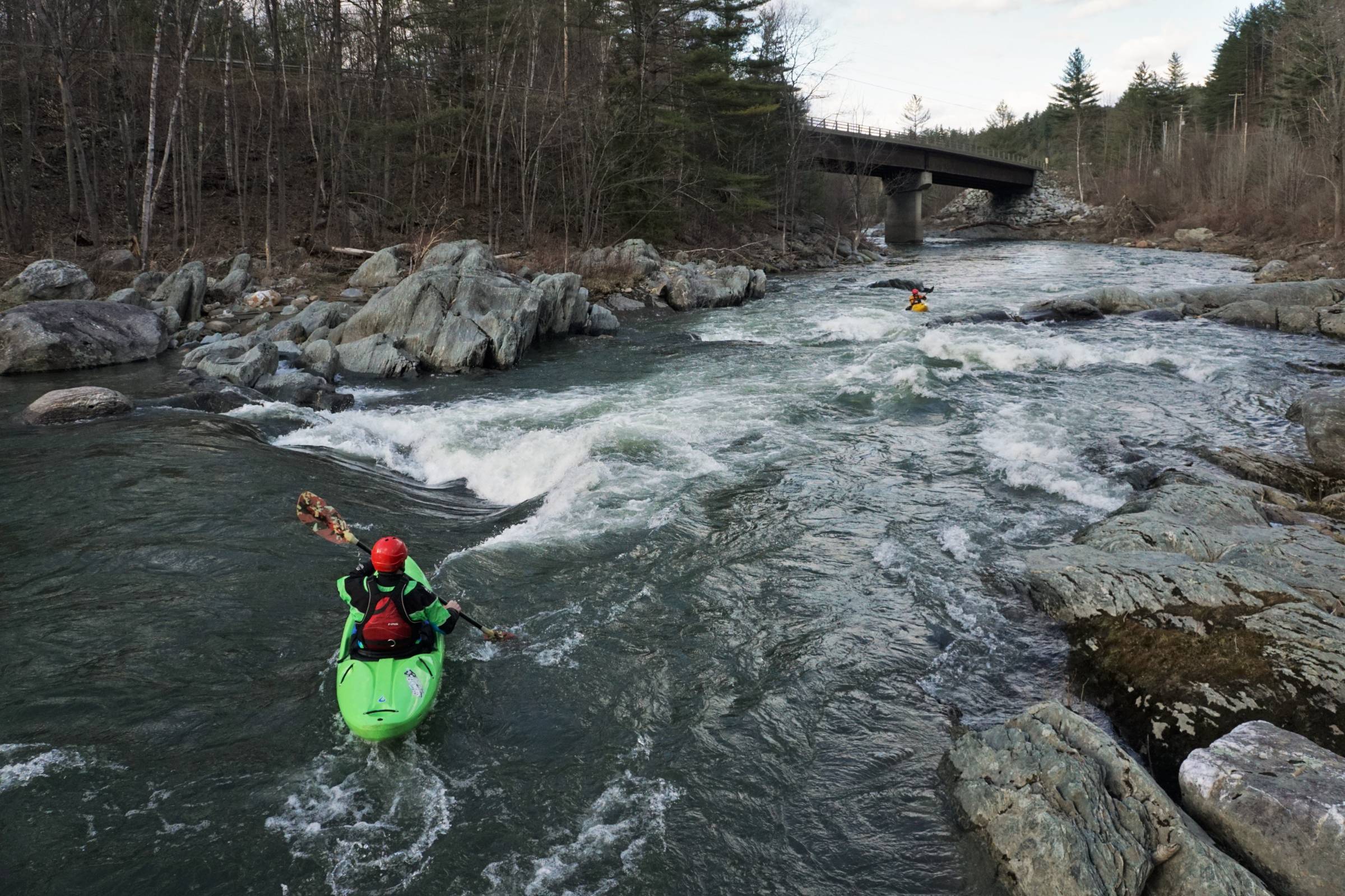
There is a short stretch of flatwater which brings you under the rt. 100B bridge from this point. Here, the river makes a river-wide 2-4’ drop over a ledge. At low flows, the most fluid line is to go under the bridge and immediately dart to river left and run the small green tongue along the bank. At higher flows the majority of the ledge opens up with the most common line being a few feet to the right of the bridge abutment. Just below this drop is a nice wave/hole in the center of the river with eddy access on both sides. 


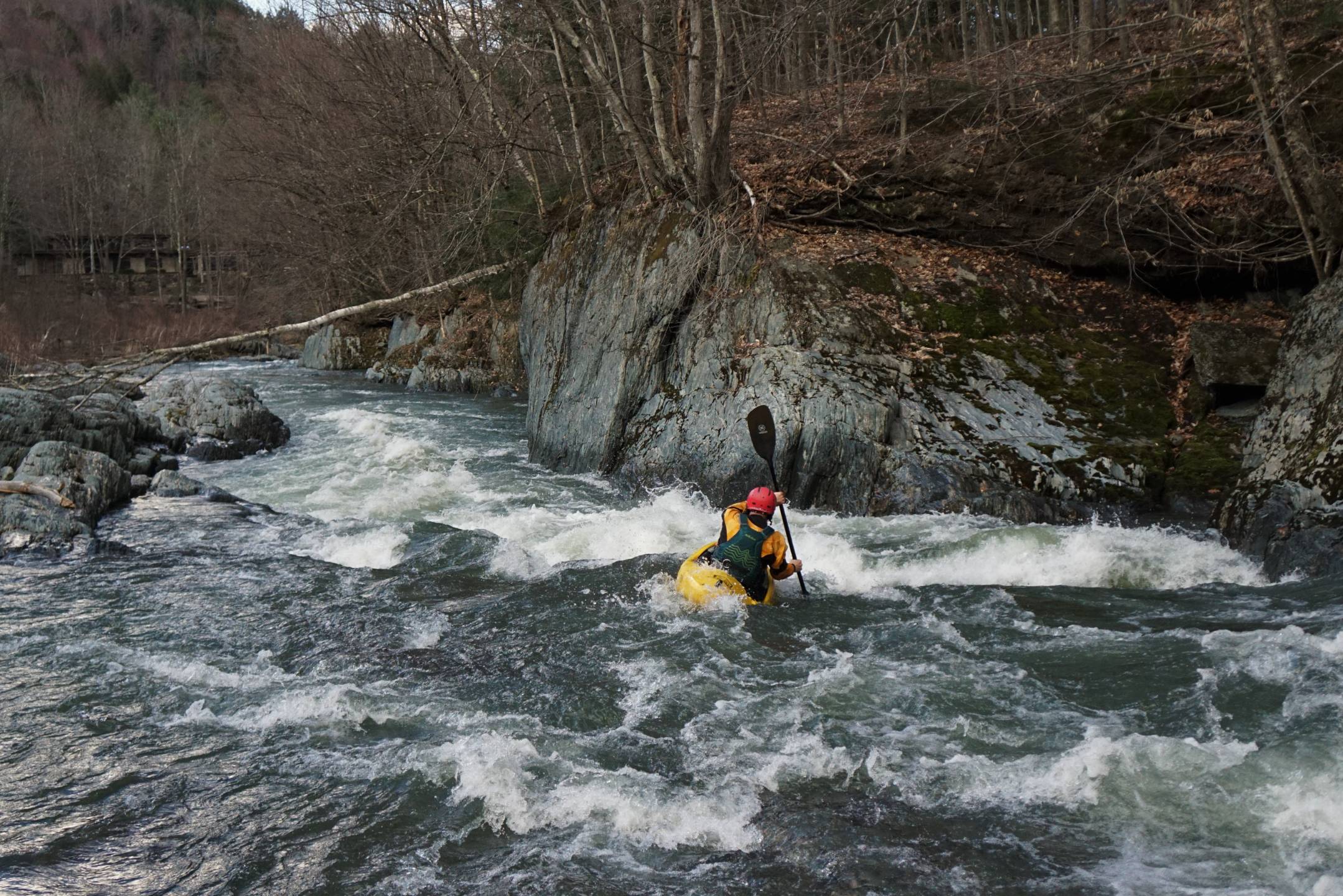
After a bit of mellow water the river makes a gradual drop for about 100 yards over many small boulders. This section seems like it should have more to offer as you approach the top, but there is not much to offer aside from a couple of small waves and some eddy-hopping. At high flows, a line on river right opens up which offers a bit more variety. 


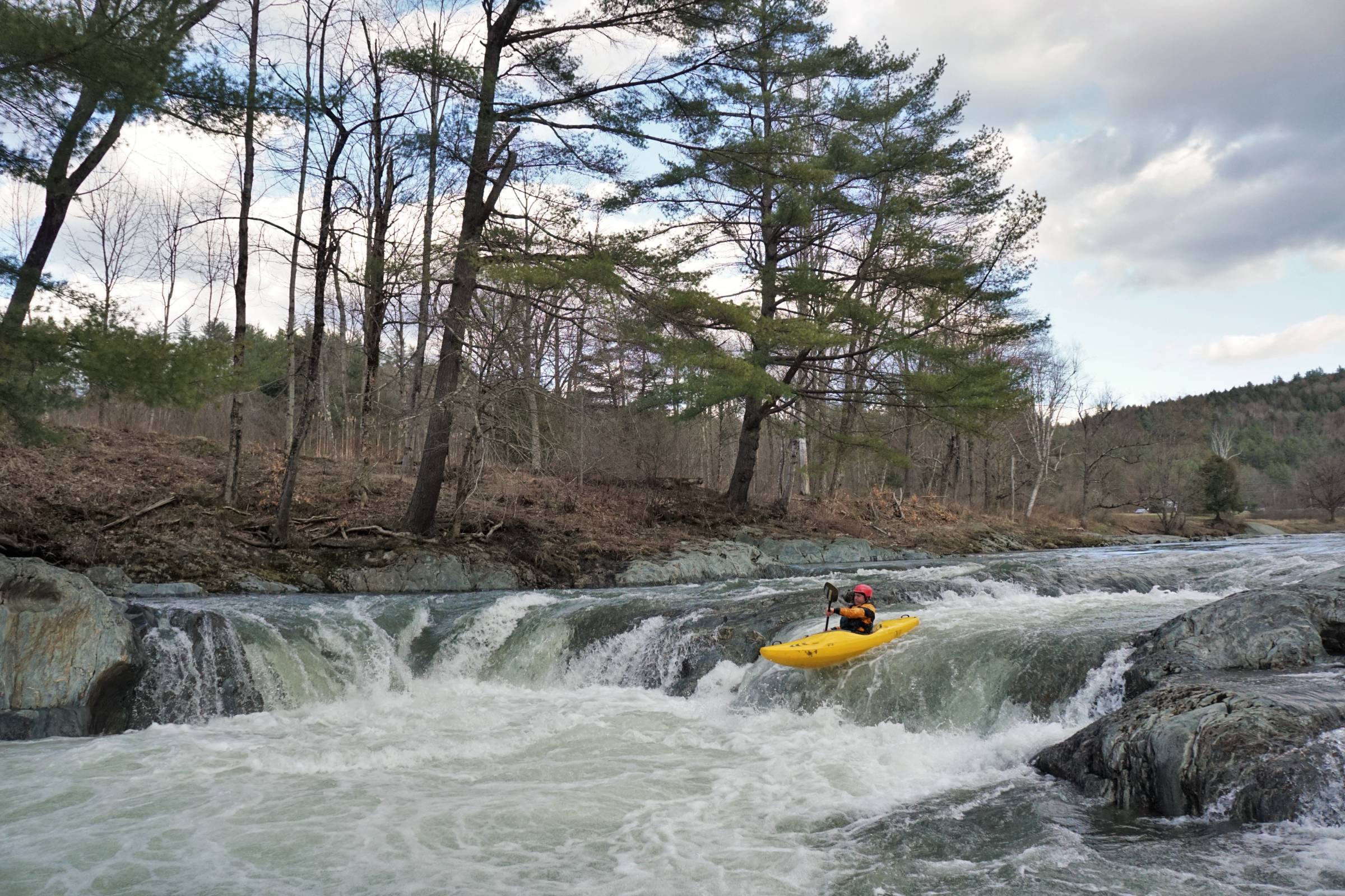
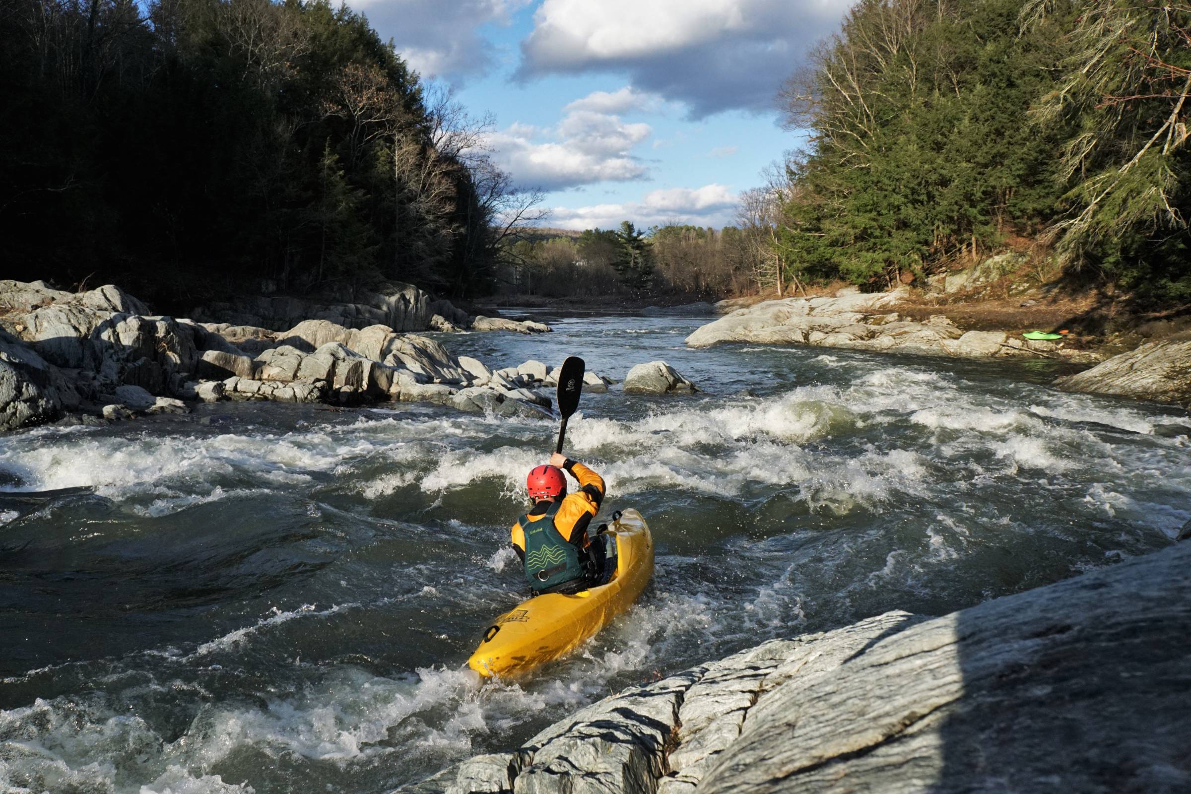
Some more flatwater brings you to an island in the middle of the river. The left side is a straight shot through some class I waves. The right side ends in a small curler with good eddy access on river right. This is a fun spot to practice spins, but beware, it is quite shallow and finding yourself upside-down is not very fun, even at higher flows. This small rapid ends at a large boulder which often collects wood. After the boulder is a couple hundred yards of moving water leading to Horseshoe Falls.

Clay Murphy running Horseshoe falls

Eddy out on river left to scout the falls and/or portage. There are two lines here. For the left line one will run close to the ledge rocks on river left and drop over a small hole into a pool above the main drop. You can run the drop straight through or eddy out in this pool first. The safest line over the main drop is about 5 feet out from the river left ledge. This requires a late boof stroke to properly clear the bottom hole. At lower flows this is rather inconsequential but at higher flows (<1000) the hole becomes super gnarly and one can easily find themselves being pulled back in for a beatdown. Avoid dropping the final falls too far toward the center maw. The water in the pool below is extremely aerated and can be tough to roll up in, especially as the flow increases.

The right side of Horseshoe is a step up and easily a class IV drop. To run this line, follow the main flow about 20’ from river right down toward the drop. The water makes almost a 90 degree turn just above the drop. One can eddy out in a micro eddy just above the horizon line to re-orient toward the river left bank, or run it straight through. The hole here is more significant than the river left line and requires more skill to run smoothly. At very high flows, this is an experienced move which can land one in a serious beatdown. Safety can be set from river left just below the Falls. Boats and paddles can be recirculated for quite a while in this hole and may require some time to save. If running this close to dark, keep in mind that a swim here can take quite a while to recoup from. Also, be sure to rescue swimmers quickly because the short pool below leads immediately into a turbulent class III drop through a mini-gorge.

This next drop, named “Washing Machine,” comes up immediately after the aerated pool below Horseshoe Falls. There is a green tongue just left of center and below the horizon line. Paddlers can eddy out on river left above the drop to get a better look from the boat. Once you have dropped in on the green tongue there will be some waves crashing in from the gorge walls which can easily flip the inexperienced paddler. This drop is fast and over quickly, with some moving water at the bottom. Below this drop the river opens up wide and makes a gradual turn toward the left into a large eddy. From here the usual line is to move toward river left and then a sharp right toward river center over a small hole. At higher levels a very narrow, creeky line opens up on river left around a large ledge sticking out from the river bed. Both lines bring you through a gradual class II drop with some small play waves at the bottom. This is not a nice area to be upside-down, as it is usually shallow with lots of boulders just below the surface.

Clay Murphy heading into Washing Machine on the Lower Mad River Vermont Whitewater Kayaking
Clay Murphy entering Washing Machine

After this last drop, the river narrows again through a small gorge-like area and under a foot bridge. It can often be a good take-out during late-winter or early-spring runs, when the pool after the bridge is iced over. That said, the land on both sides of the river just above and below the bridge is posted. This area stays deep even at very low flows, and can be a good spot if one is desperate for an eddy line or spot to practice rolls deep in the summer. 


After the bridge the river opens up wide again with a house perched far above the river-left banks. There are a few lines here at varying levels- all easy and without consequence. At very high flows there can be some interesting boils and wild eddy lines looking to flip someone when they are off-guard. The most common line is to hug the river right ledge wall and skirt the edge of a small hole via a green tongue against the wall. A short bit of moving water brings one to the final drop.


There will be a large island left of river center. The line to the left of this island is ~6-8’ wide and a quick creeky drop over a couple of small holes with a nice little wave at the bottom. The right side of the island is a step up and a good bit wider.

Clay Murphy running the final rapid on the Lower Mad River in evening sunlight. Vermont whitewater kayaking.
Clay Murphy on the last rapid of the run in early evening spring sunshine.

 The river makes an abrupt drop over some large boulders here, with the main flow heading directly into a large ledge wall and then moving toward river left below the island to meet with the water coming from the island-left line. This drop has a couple of micro eddies which can be fun to catch, the first being immediately below the horizon line on river right. The holes here are small and inconsequential. The most common straight-shot through is to drop in just right of center and to just paddle through and over whatever comes your way. This is also not a fun place to be upside-down, especially at lower flows. The bottom of this drop (right side of the island) has a nice wave with a hole just above it, both of which offer up some solid surf. A late roll here can find one pressed against the ledge wall below rather quickly at high flows. There is eddy service on both the surfer-right and surfer-left sides of this wave/hole. The surfer-left side often collects wood and can be rather tumultuous at very high flows.

Just below this final drop the river meets with the Winooski. Two thirds of a mile of flatwater paddling will lead the paddler under a bridge and the take-out will be on river left at a small outcropping with a well-maintained trail leading to the parking lot. During late-winter/early-spring paddling this takeout can be congested with giant icebergs which make getting out and up to the parking lot difficult. 


Overall, this run is excellent for all ranges of experience levels. There is a decent amount of play throughout and it is a great playboat run as a result. There are many uncommon moves to be found if one is looking to make the most of this run, and the Falls are especially easy to lap for boof practice and the like. Newer paddlers will find this to be the perfect training ground, even if they are simply practicing ferrying and light surfing at the put-in. 

Stepping Stones

Creek VT river guide coming soon
Not quite ready for The Mad? Otter Creek is a great place to build confidence.
Creek VT river guide coming soon
If you like The Mad, then you're sure to enjoy the West River
Creek VT river guide coming soon
Looking to step it up? The Lower Moose in St. J is a fun next step.